
Since the Richter Scale and was last applied using Moment Magnitude scale,
This is the Top Ten Largest Earthquakes since 1900 |
| Gempa bumi JEPANG , Sendai, honsu march ,11 2011 |
updated april 2011

 1. CHILE on 22 May 1960 with an earthquake measuring 9.5 magnitude and take life more than 1600 people, occurred on the coast and triggered a tsunami up to Japan, Hawaii, and also the Philippines and caused casualties of 170 inhabitants. and this The Largest Earthquake in the World / the largest earthquake in the world.
 2. ALASKA , Prince William Sound on 28 March 1964 with magnitude 9.2 magnitude earthquake and tsunami followed, causing the victim only 128 inhabitants.
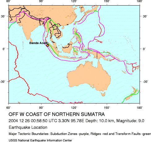 3. INDONESIA, offshore 250 km (155 miles) west of aceh sumatra north with a depth of 30 km. on dated 26 December 2004 with 9.1 magnitude earthquake followed by tsunami that swept the country Indonesia (Aceh), Sri Lanka, India, Thailand, Somalia, Myanmar, Malaysia, Maldives, Tanzania, Bangladesh, Seychelles, Kenya, Madagascar and Mauritius. raises the total casualties at over 200,000 people
  4. JAPAN, near the east coast 130 kilometers (80 miles) from Sendai, honsu with a depth of 24 km. on 11 March 2011 with magnitude 9.0 magnitude earthquake
  5. Russia, Kamchatka peninsula, on 4 November 1952 with an earthquake measuring 9.0 magnitude, followed by a tsunami that just destroy some physical material properties in Hawaii, Honolulu and Pearl Harbor, and no reports will be casualties, and until now I blogging about this, magnitude calculation is still in the recalculation, because it is still in doubt the validity of between 9.0 or 8.2.
 6. CHILE, offshore bio bio 95 km (60 miles) northwest of Chillan, on the 27th of february 2010 with magnitude 8.8 magnitude earthquake at a depth of 35 km, followed by tsunamis and make casualties as much as 577 people and destroyed hundreds of thousands of homes and buildings .
 7. Ecuador, off the coast of Ecuador and Colombia, on 31 January 1906 by an earthquake measuring Magnitude 8.8 (still in its validity re count), followed also by the tsunami, which killed between 500 to 1500 deaths in Ecuador and Colombia.
 8. Alaska, in rat and adak islands, on the 4th of february 1965 with magnitude 8.7 earthquake followed by tsunami also 7.10 meters tall, there's no soul in this incident report, the population is possible because there tends to be very little, only the physical building and landing runway on the island shernya and atu.
9. INDONESIA, Sumatra 205 km north northwest of Sibolga, on 28 March 2005 at a depth of 30 km, with magnitude 8.6 magnitude earthquake followed by tsunami that caused the victim soul 1300


HOW SCIENTISTS MEASURE THE EARTHQUAKE ?
What is the difference SR and magnitude?


Richter Scale or SR is defined as the logarithm (base 10) of the maximum amplitude, which is measured in micrometers, from seismic recordings of earthquakes measuring instruments (seismometers) Wood-Anderson, at a distance of 100 km from the center of earthquake. For example, suppose we have an earthquake recordings (seismograms) of the seismometer is installed as far as 100 km from the center of earthquake, the maximum amplitude of 1 mm, the strength of the quake is log (10 ^ 3 micrometer) is equal to 3.0 on the Richter scale. This scale was proposed by physicist Charles Richter.
Richter Scale is only suitable for earthquakes close to magnitude 6.0 earthquake beneath. On top of that magnitude, these calculations by Richter techniques become no longer representative.
Keep in mind that the calculation of magnitude quake on the Richter not only used a technique like this. Sometimes misunderstandings in the news in the media about the magnitude of this earthquake because the methods used are sometimes not mentioned in the news in the media, so that it can be between one institution with another institution that is not out of the same magnitude.


Force or moment magnitude scale (abbreviated as MMS, denoted as MW) is used by seismologists to measure the size of large earthquakes in terms of its energy when released in an earthquake, which together with the stiffness. Earth multiplied by the average amount of slip on the fault slip and the size of the area.
introduced in 1979 by Tom Hanks and Hiroo Kanamori as a substitute on the Richter scale in 1930-era (ML).
so his conclusion for now is a standard size of an earthquake is the MOMENT magnitude and become a reference for all scientists geology and the U.S. Geological Survey .
richter scale : a rating of an earthquakes magnitude based on the size of the earthquakes seismic waves
moment magnitude scale : a rating system that estimates the total energy released by an earthquake


Strong earthquake in Japan that caused the tsunami on Friday, has shifted the main island of Japan, as far as 2.4 meters and also alter the earth's axis as far as 10 cm.

how earthquake happen ?
how tsunami happen ?
1 comment:
Semoga tidak terjadi lagi gempa bumi dan tsunami di jepang.
Post a Comment